Des Plaines River Fishing Spot
- Elevation: 665'
- Last Modified By: vinny60 on 09/09/09 05:25 PM
- Ask about Des Plaines River in our Fishing Forums
Photos
Fish Species
Comments
-
There are two boat ramps that can accommodate trailered power boats:Plank Woods (at Ogden and 1st Ave). (north of Plank Woods, Salt Creek to the west) Burr Ridge Park District (on Madison south of 97th). Canoe/kayak only ramps at: (these are carry-in ramps) Russell Road (Lake County) Wadsworth Road (Lake County) Route 173 (Lake County) Route 60 (Lake County) Stony Ford (Cook County) Columbia Woods (Willow springs rd north of Archer). Lemont Landing Isle al la Cache (Will County). Lockport Nature Preserve, Division Street [Dirt take out point, no ramp] (Will County) Generally, you can put in and take out at any forest preserve in Cook County that borders the river.
Des Plaines River Description
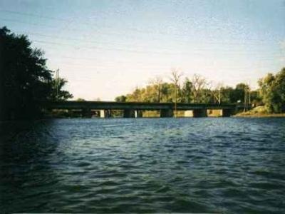
The Des Plaines River flows southward for 150 miles (241 km) through southern Wisconsin and northern Illinois in the U.S. Midwest, eventually meeting the Kankakee River west of Channahon to form the Illinois River, a tributary of the Mississippi River. The slow-moving Des Plaines River rises in southern Wisconsin just west of Kenosha and flows southward primarily through marshland as it crosses into Illinois. The river turns to the west and flows through woodland forest preserve districts in Lake County and Cook County (and through the city of Des Plaines), northwest of Chicago. There are numerous small fixed dams on the river starting in central Lake County and continuing through Cook County. Eventually, the river turns to the southwest and joins with the Sanitary and Ship Canal in Lockport before flowing through the city of Joliet. In the heavily industrialized area around Joliet, dams control the river. Just west of Joliet, the Des Plaines converges with the Kankakee River to form the Illinois River. Parts of the Des Plaines River preserved in a mostly natural state are used for conservation and recreation, while substantially altered sections serve as an important industrial waterway and drainage channel. While canoe launching ramps are available, "The lack of ramps for trailered-boats makes this long river a quiet, family-friendly river." The Des Plaines River can be divided into sections with distinctly different personalities. The section above Lyons is a mostly narrow river, twisting and turning its way to the south. Between Lyons and Lockport, the river is non-navigable and mostly channelized. Except for the areas between the Hoffman Dam and the North Avenue Dam, and the Burr Ridge Ramp and the rail bridge, there isn't a place for trailered motorboats to be put in the river. Above the Hoffman Dam, the river is deeper, slow moving, with little current. Below the dam, the river is much shallower. At Stony Ford and Lawson Fords, you can walk across the river. The land adjoining the non-navigable portion of the river is mostly forested and includes many forest preserves. One notable exception to this is in the city of Riverside, where many homes are located right near the waterway. As the river takes its turn south near Romeoville, it forms a large pool with un-river like characteristics. Instead of moving current and waves standing still, it takes on lake like waves. The river becomes quite wide and shallow. Shortly after you exit the large pool (about 1 mile long), a large island will appear in the center. This is Isle a la Cache nature center. If you travel to the right, you'll find a museum and canoe launch where you can stop (if the museum is open) and get fresh water and use the facilities. Isle a la Cache is the only remaining island on the river, the others (the largest of which was Prescott Island near Lyons/McCook) have had one of the rivers channels landfilled and are now covered with homes and roadways. The original pioneers wrote of the Isle as a landmark in their logs and should you stop there, you will no doubt be following the footsteps of many before you. Beyond the Isle, a series of sluice gates connect overflow from the Ship and Sanitary Canal to the Des Plaines river, increasing the river's flow. At this point,the river also begins its 20-foot drop to the level of the Ship and Sanitary Canal. The river and the canal join south of the Lockport Lock. Just after you pass under the Illinois 7 bridge, a series of small islands appears. This area, due to the increased flow, rapid drop, and compression of the islands is called the Fishnet Rapids (the islands make a fishnet-like pattern, and the water flows rapidly). Just past the rapids, the River joins the Ship and Sanitary Canal Channel. This section of the river is navigable and home to many power boats. As the river flows thru Joliet, large gambling casinos travel the river as well as river tugs, pushing their strings of barges. This section is very industrial, and most of the area has corrugated steel vertical walls, making take-out points hard to find. Fish in this River include: Northern Pike Largemouth Bass Bluegill Sunfish Bullhead Catfish Channel Catfish Carp Crappie
The Des Plaines River flows southward for 150 miles (241 km) through southern Wisconsin and northern Illinois[1] in the U.S. Midwest, eventually meeting the Kankakee River west of Channahon to form the Illinois River, a tributary of the Mississippi River. Des Plaines is French for "of the plains" or "of the prairie", but it is pronounced phonetically by locals (with no silent letters), rather than using the French pronunciation.